2016-03-09

Maps at La Cruz de Huanacaxtle

The Riviera Nayarit Roadmap and others are currently available at the Mercado Huanacaxtle in La Cruz de Huanacaxtle, Nayarit. Look for Bill and Victoria's table, which also sells dried mango, spices, and field guides to the flora and fauna of Mexico.


2016-01-21

Old Prints Now Available on Etsy


It's been 10 years since the first map of Yelapa. To celebrate, Mapa Jeff has made a small number of pristine leftover prints from yesteryear available on his Etsy store.


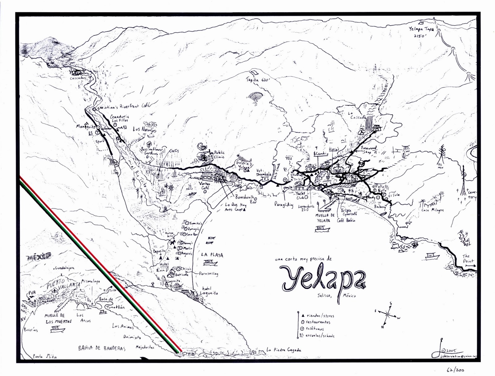
YELAPA 2005:
Signed edition of 200 prints. Printed in Mexico. Three left.

YELAPA 2010: 
Thick, sturdy prints from the last black-and-white edition. Printed in Berkeley. Ten left.

 YELAPA 2011:
The first edition in color. Printed in the US. Three left.

YELAPA 2014: 
Mapa Jeff's personal favorite, with deep aqua seas and a green border. Printed in Mexico. Two left.

YELAPA 2015:
The last of the one-sided color poster prints, laminated and waterproof. Printed in the US. 20 left.

PUERTO VALLARTA WALKING MAP 2010:
A memento of a fast-changing city, with the old Los Muertos pier.
Laminated. Two left.


Mapa Jeff also has a few prints left from the truly horrible 2006 printing, with the smudges and whiteouts, which nonetheless sold because of course, there is no other Yelapa map... price is flexible. Very flexible. Enquire how to get one at mapajeff@hotmail.com.


2015-11-16

ANY THREE MAPS: $25 SHIPPED

Don't go to Puerto Vallarta without them.

Take the best maps available - now at a discount for any three titles (or three copies of one title).


New for this season:

Coming in 2017:


2015-10-28

Vallarta's Waterfall at Agua Azul

There are many, many smaller waterfalls about Vallarta - a couple of them visible on the way up to this one. But this is the biggest and the most waterfall-ish... pouring down from somewhere high up. At this tine of year it can be seen in full roar from the Libramiento on the way into the Tunel.


2015-10-14

The New Flagship Map

Compact folding maps are here.

The new generation of Mapa Jeff maps is designed for easy shipping, portability, and lower cost - while retaining their unique, thorough, panoramic perspective on the land.

The new Puerto Vallarta Centro & South Coast Walking Map features the Old City on one side, and the coastal neighborhoods from Amapas and Conchas Chinas all the way to Playa Los Arcos on the other.

Condos, villas, hotels, public beaches and public parking, landmarks, restrooms, and many other details are included. But as ever, there is no advertising, no sponsor, and no agenda:
Just the facts on the ground, researched and illustrated by one artist.

Folded size: 5 x 7 inches.

Side A: The Old City, extending north to the Sports Stadium and east (for the first time) to Paso Ancho.
Unfolded size: 14 x 20 inches.

Side B: Amapas, Conchas Chinas, and the beaches south to Los Arcos National Park.

The Centro, Plaza, Church of Guadalupe, and Isla Cuale:

North of the Centro: Cinco de Diciembre, Calle Lirios set in its folded hills, and the beachfront parks.

Northwest of Centro: Libramiento, Cemetery, the city's only waterfall with clear walking directions.

The neighborhoods hugging the riverbanks to the east of the Old Town.

Paso Ancho, a quaint hillside enclave on the river just past Colonia Buenos Aires.

Conchas Chinas' twists and turns are clearly illustrated amidst the lower slopes of La Torrecilla.

El Nogalito, a tiny riverside village tucked away in a coastal valley:

Garza Blanca, with its resorts and beaches:

2015-07-12

PV Hotel Zone / Marina Vallarta Walking Map

 Compact folding maps have arrived.

By popular request, I am publishing maps of the northern areas of Puerto Vallarta this season.
They fold into a convenient 5x7" size.
The first will feature the streets, pedestrian paths, footbridges, parks, churches and other scenic elements of the Hotel Zone and Marina Vallarta, in the highly detailed, panoramic style already well known from my Puerto Vallarta Walking Map of the old town.
Of particular interest are the clear markings for all public beach access points.

Because of their compact size, the new foldable maps can be received at Mailboxes Etc. boxes in Mexico as letters, rather than packages.

Click here to buy this map online.

Click on the images for full-size viewing on any device.


On side A, the Hotel Zone, Fluvial, Versalles, the Aramaras and (in the top left corner) Pitillal:


On side B, the Marina, PVR, and an inset map showing key sites of interest around the airport:


 The inset map shows how to reach the International Convention Center, the Central Camionera (intercity bus terminal), and the Transito Municipal, where parking tickets paid within 24 hours are half price. (Another reason to love Mexico.)

The cruise-ship terminal, with gates and taxi stands clearly marked for the traveler:

2015-06-12

Yelapa 3.0

The prospect of an online community project spurred me to overhaul the Yelapa map this summer.

The new drawing, modeled after satellite imagery, takes fewer liberties than previous editions with the actual spatial relationships on the ground. The retail map will folded, double-sided, and larger at 14 x 20 inches - making it no longer necessary to squeeze the kaleidoscopic breadth of Yelapa onto one rectangle as I have done in the past.


The second side will feature the small regional map as a cover plate; a map and directions to the Upper Waterfall; a detailed closeup map of the Pueblo extending to the arroyo at Shambala; and likely some basic information about visiting Yelapa.

There are plans afoot to include rental housing for a small fee on both the retail and online versions of this map. If you are interested in signing up, please contact me at mapajeff@hotmail.com.


Here by contrast is the 2015 edition, the last one based on the 2008 pen drawing. From edition to edition, I have gradually put more and more elements into digital form, now setting all text in my own font, Mapa Jeff Basic.


In 2008, I introduced this map and only began coloring it for the 2012 edition. People have often asked me for copies of this old style, and I miss its simplicity, but there is no going back:


The 2006 edition was based on the first drawing (measuring only 9x12 inches), with edits hand-drawn and taped over the original:


The very first edition was introduced in 2005 with a print run of 100 signed copies. The original drawing, on a 9x12" Stratmore sketchpad leaf, still exists, toned beige unlike this print: